Saturday, May 31, 2025

Geotagging Charger Stations to see on Android Auto OsmAnd

 Searching for EV charging stations seems as much an art than a science so far. My flexible vehicle display provides searches from the manufacturer, and through Android Auto Google Maps and my installed OSMAND Android app.

What I'd like to see at a minimum I have through my own favorites shared as a KML file over Dropbox. Bit of work, and worth it so far for me.


I found when OsmAnd shows favorites, they are in alphabetical order, and no more than 10 are shown no matter how many are in the KML file. I've split my chargers list by brand in order to view all of them, even in the fractured level way. This example shows only Shell EV stations.

The map is useless, going from Hudson Bay to Venezuela, and there is no way to sort by distance, only name. Clicking on one item gets to navigation, with no map view in between.

Multiple chargers in one spot gets the worst result with OsmAnd Points of Interest for chargers.


You can see 10, but only 4 at once...

Some useful places to avoid, though, in later content.


At least on the POI view a map can appear. Not that you can zoom, pan, or otherwise affect that landscape shown behind the list while in motion. Or stopped at a light, as all of these shots were.

Only one field in the OpenStreetMap data is shown on the favorites list; thus I have refined what that should include, given space, mnemonic devices, and community standards. After I finish "just a couple more" on OSM edits I will reload my local phone map store and see what I've sown.


Tuesday, May 27, 2025

Bake-off - Mapillary and Panoramax

 Comparing 2 photo geolocation upload services, I considered dropping use of Mapillary if an equivalent portal exists beyond Google or Apple photos, first running into an incompatibility of graphic formats. The workaround was an un-edited image.

Panoramax authenticated through OpenStreetMap. 


4 strikes and out. Meanwhile the same image went into Mapillary in parallel.


After figuring out MS Paint edits mangled the GPS tags, the image stuck in Panoramax.


OpenStreetMap, local fork er spork off.

The panoramic image is off with only one in the sequence.

I uploaded an image with a license blurred, and Mapillary blurred it some more. In Panoramax, the plate was not blurred at all. 

The poll I ran heavily favored not using Mapillary. Including links to Mapillary on the main app/map page favors images on that site, though.


Other than the oddity of image-stretching, and the variation in blurring, both seem acceptable. I will try to use Panoramax with a few more EV charging stations, adding more useful details and missing stations.

Wednesday, April 9, 2025

Food Service Mapping

Food banks run by charitable organizations are a public service where private entities fill in where government runs short. Picking up, storing, and sharing food throws lifelines to those in need. I volunteered to create updated maps for Scouting America and decided to use QGis and related software tools.

(1) OSM

Going from the lowest level up, I added OpenStreetMaps (OSM). This is an easy drag-and-drop from the base QGIS sources into the current project. Depending on the desired result, I change the transparency from none to 50% more or less.

The standard OSM layer sources from openstreetmap.org. I've found, using tools like Viking, that variations on the main source can be used, and I prefer to try the Humanitarian one. Eventually I found the wiki page which let me set the feed, like this:

https://wiki.openstreetmap.org/wiki/Raster_tile_providers

https://a.tile.openstreetmap.fr/hot/{z}/{x}/{y}.png

(2) Org

The second layer is the organization table. These have street addresses in the source, so I geo-located them with a Census Bureau tool that works via command line.

Once located, the QGIS data are converted to geometry. In a PostgreSQL database, I imported organization details, which had only street addresses not geo-data. To convert from the address to a lat/lon point I found a Census page that I could script.


$ lynx -dump "https://geocoding.geo.census.gov/geocoder/locations/address?street=10001%20Bird%20River%20Rd&state=md&zip=21220&benchmark=2020"  | grep Interpolate
   Interpolated Longitude (X) Coordinates: -76.432431362395
   Interpolated Latitude (Y) Coordinates: 39.356117523642

Ran the conversion steps and viewed points and polygons.  Once the latitude and longitude are set, the PostGIS function to make this into valid point(s) I used is:

UPDATE org.org SET geom = ST_SetSRID(ST_MakePoint(lng, lat), 4326);

(3) Tract shapes

Next level layer shows US Census tracts. I found a couple sources of these shape files, and used the Maryland State data.

https://www.census.gov/cgi-bin/geo/shapefiles/index.php?year=2020&layergroup=Census+Tracts


[omitting how to add this layer from ZIP or shape files]

To match the boundaries of the local district I wrote a filter, first including only Baltimore County tracts and next excluding specific tracts not in scope.

QGIS lets me save and load a filter definition, more or less a SQL code snippet.

<Query>"COUNTYFP"='005' and "tractce"  NOT IN (
        '400100',
        '400200',
        '400400',
[...]
        '494201',
        '494202',
        '980000',
        '980100',
        '980200',

        '9999999999'
)
</Query>

The blank line prior to the query end lets me run a unique sort to more quickly find gaps and add or subtract tracts.

(4) Unit Tracts Coverage

The coverage mapping uses a simple table with tract and unit/organizations. In order to connect these to the tracts I created a view.

Sunday, March 9, 2025

The tertiary phase: 3 Maps in One Vehicle

osm-and-auto-map

New to me EV has built-in GPS and navigation system. Android phone in car has GPS, and google map navigation routing system. Phone cannot access car GPS, to avoid duplication of effort. Car navigation map data might be aging, no updates without manual effort. Google maps keep personal placemarks, intentional or not.

Aim

Create a list of nearby charging stations with ratings, cost, owner/operator.

  1. Just use Google
  2. Use Google as little as possible (on an Android phone with GPS switched on)

For Option 2 I got 2 suggestions:

  1. - OSMand
  2. - @jspath55 Tried `Organic Maps`? @organicmaps 
    1. Uses OpenStreetMaps: https://organicmaps.app/

I could not get  Organic Maps to do Android Auto, so OSMand was left to try.

https://osmand.net/docs/technical/osmand-file-formats/osmand-kml/ shows the general path I took using Google Earth and QGIS as alternate ways to produce a set of points.


Web site said $40US to connect to Android Auto. 3 tiers: free, one-time, subscription. Free version could only load a limited number of "offline" local maps (which has not been my experience so far).

Details

Use Viking and/or QGIS to record my points of interest (charging spots).

  • Keep data in PostgreSQL database.
  • Edit/view via LibreOffice.
  • Export KML from QGIS, import to OSMand.

It has been a (rough) year since I worked on a town map, pulling in layers of county land info. Points and lines in a SQL structured database with QGIS access (R/W). First table create showed up a "non-geo". Icon was a table/sheet instead of dots, lines, or blobby GIS areas.

Second try was no better success than the first.

On the third try, I copied a table definition from an exported table that had geo-goo.

                        Table "public.chargers"

    Column    |         Type          | Collation | Nullable | Default

--------------+-----------------------+-----------+----------+---------

 station_id   | integer               |           | not null |

 address      | character varying(40) |           |          |

 zipcode      | integer               |           |          |

 brand        | character varying(40) |           |          |

 vendor_id    | integer               |           |          |

 grade        | character varying(12) |           |          |

 price        | double precision      |           |          |

 visited      | date                  |           |          |

 updated      | date                  |           |          |

 lat          | double precision      |           |          |

 lon          | double precision      |           |          |

 the_geometry | geometry(Point,4326)  |           |          |

 kwh          | double precision      |           |          |

 name         | character(40)         |           |          |

 note         | character(80)         |           |          |

Indexes:

    "chargers_pkey" PRIMARY KEY, btree (station_id)

Check constraints:

    "chargers_geometry_point_chk" CHECK (st_geometrytype(the_geometry) = 'ST_Point'::text OR the_geometry IS NULL)

Finally able to add points and see them on the map. So far, no dice adding data points from LO that show on the map.

Next step: export map layer of points as a KML file.

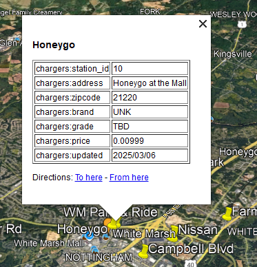
First import to test on Google Earth showed every location called "noname".

Some data fields peeked through as table-like sheets in Google Earth on a PC, but less structured on a tablet:


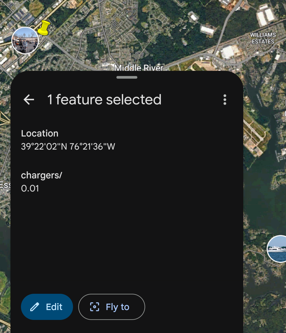
Load into OSMand from a network drive, and yes, places show up under my favorites. Added a "name" column to the underlying table fixed the "noname" issue.

Using the OSMand app as a driving map is slightly different than the car map or the Google map. The colors and details are clearer. Startup is more complex, but does work.


Oddities:

  1. Route going through driveways
  2. Non-connected road shows as "take the left fork"
  3. Stream flow direction


The above stream shows 2 directions, as if at the top of a hill, or mound (blue arrows on blue dashed line).

Next question(s)

Use OSM data format instead of KML.

Is location data still going off-device? Will this option change that (limit or redirect)? Seems a lot of on-device processing based on battery drain (or charge slipperiness) and heat.


Wednesday, December 25, 2024

Not the Top Ten Bengies List You're Looking For


The top ten list is traditional, though not guaranteed, as I learned this year. In prior years there were plenty of shows to see so the picking of the top 10 was challenging. I would know which movies I enjoyed and the others. 2024, though, was a challenge to find 10 movies we saw at the Drive-In. 

The list that follows is basically in chronological order, running from March to December,  practically 10 full months. We skipped the dusk-to-dawn shows, or we could have added another 8 or so to the list.


MARCH
Bob Marley One Love


JUNE
INVASION OF the body SNATCHERS. 


INVASION OF THE BODY SNATCHERS (1956)
THE MAN WHO KNEW TOO MUCH


Scooby-Doo Doo and the BARCS


JULY
LION KING 1994
Inside Out 2


SEPTEMBER
Scout Drive In Camp In


BEETLEJUICE BEETLEJUICE
LITTLE SHOP of HORRORS


DECEMBER
Wicked
RED one


In retrospect, One Love was a standout; Red One was better than anticipated, and Little Shop of Horrors survived the test of time. I saw BEETLEJUICE twice, almost 3 times., but missed the original when it ran. See you next year!


Sunday, November 3, 2024

Third and inches

 The football expression is fourth and inches, so this is not a sport tale. Making a loom required 3 teeth per inch to get 19 across a 7 inch span conforming to the available loops. Imperial scale rules don't help, and rather than get out the metric equivalent I drew a quick sketch in LibreOffice then exported to PNG and PDF.

ODG:

And the works-in-progress at camp:


4-sided loom:
Hammering teeth


Teeth on edge


Two sided loom:


The finish line.


Lining up for pre-drilling in clamp. 

Saturday, September 28, 2024

Flipping Zabbix from NetBSD to FreeBSD

 I wanted to upgrade my Zabbix server running on a NetBSD amd64 host and at almost the same time install NetBSD on an NVME card instead of SSD. The mainboard has no graphics, so I played hit-or-miss with cheap-ish cards, getting NetBSD 9 to run but then not, and using FreeBSD under low-res VGA mode. Anyway, to avoid missing data in case the reinstall had surprises I decided to clone the running Zabbix system to a FreeBSD host on a recycled laptop.

NetBSD pkgsrc has Zabbix 6.0, which I'm running, with 6.4 in the work-in-progress prep area, that I have tested but not deployed. FreeBSD has 6.4 in ports, with the modules I've used so the copy would also test the auto-upgrade.

Export and import with PostgreSQL was quick and tidy once I set up the target with an empty database and the necessary glue. The export file was just over 1GB, and imported with no (visible) errors. Starting up the 6.4 server triggered upgrade steps, also showing no noticeable gaffes.

 75396:20240925:142052.283 hosts_name_upper_update trigger for table "hosts" already exists, skipping patch of adding "name_upper" column to "hosts" table


 75396:20240925:142052.877 completed 99% of database upgrade

 75396:20240925:142052.890 completed 100% of database upgrade

 75396:20240925:142052.891 database upgrade fully completed

 75406:20240925:142053.025 starting HA manager

 75406:20240925:142053.056 HA manager started in active mode

Then a bunch of agent connection errors since I was going to configure them after rather than before. Next, install of the front end pieces, and http server, and the PHP bits and pieces to access the console. Happily no unsurmountable hurdles, made easier by having a running system to compare against.

IMAGE 1


Yay, history moved over intact. The dashboard shown was defined to show NetBSD Rasberry Pi wi-fi and that definition also survived the transfer.

IMAGE 2


The down-time, which wasn't optimized as I was not in a hurry. A few hours max. 

IMAGE 3


Because this was a new server, the out-of-the box poller configuration needed a little tweaking, handled over the shakedown phase as agent loads increased.

IMAGE 4


The first unexpected result was having empty Zabbix Server dashboard panels. There should be charts on each of those sub-frames, and also a log of messages near the top.

IMAGE 5

The prior widget definitions had pointed to "Zabbix Server" or a specific hostname. A definition distinction I didn't fathom until forced to repair the above. Doing a web search for terms "zabbix", "server" and "dashboard" was a time-waster given their generality.


The other built-in dashboard revealed the source hostname instead of the target. I scratched my head, read the docs, and left un-illuminated. I forced a fix by updating the various panels to point to the new server, knowing that the next move will trap me the same way.

IMAGE 6


Once I have set up a valid "Zabbix Server" target I can go back to the red loading zone and re-patch.

IMAGE 7

Once the gap was ID'd I set up a couple then completed the remaining sub-panels.


Initially, a valid working alert came out, leading to a side-bar investigation of kernel process limits.

IMAGE 8


Zabbix predefines macros that appear tilted to modern system eyes.

IMAGE 9


Colors and numbers and pop-ups oh my! The next question is which NVME board for NetBSD 10?