We collected data about stormwater sediment conditions in the Bird River area during the weekend of November 15 and 16, 2014. We were given directions for paper notes, and how to take pictures of what we observed. I'm going to turn in the paper, but it's faster to make it available online, and I can correct any paper note errors by looking at the sites in Google Earth or maps, or other mapping schemes, including USGS maps.
Saturday we looked at a more developed area, so we saw no construction sites. We did record 5 stream crossings. Several are near the Beltway, and it is obvious from their age they are ripe for a little attention.
Point 1 is White Marsh Run going under Avondale Road, next to I695.
Saturday we looked at a more developed area, so we saw no construction sites. We did record 5 stream crossings. Several are near the Beltway, and it is obvious from their age they are ripe for a little attention.
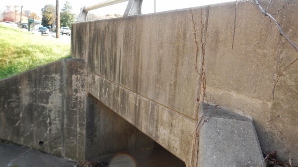
Point 1 is White Marsh Run going under Avondale Road, next to I695.

Point 2 is another sturdy bridge, East Avenue.
Third, a trashy, overgrown, logjammed old canal, complete with direct downspout connections (not illegal, but probably against the spirit of anti-pollution laws.

Point 4 - Orbitan Road - 100% paved over on this side.

Point 5... nearby, but logjammed.

Six, the edge of Oak Crest Village...

None of the above have obvious muddy water. Which is to be expected in areas built up 50 or 60 years ago. It had not rained in a week. Which is why coordinates such as 39° 21' 58.11" N 76° 25' 9.51" W are better in type than in blue ink.
I've tried to link each image with the uploaded picture on Panoramio, but will recheck the validity after a while.
Sunday, we traveled to areas with new construction. More to report.
Not so many stream crossings. The area is flat and even marshy, but the new MD 43 interchanges were built up, graded, and engineered with new drainage.
Site 1, Pipe 1.

Fast forward to pipe 2, Bengies Road

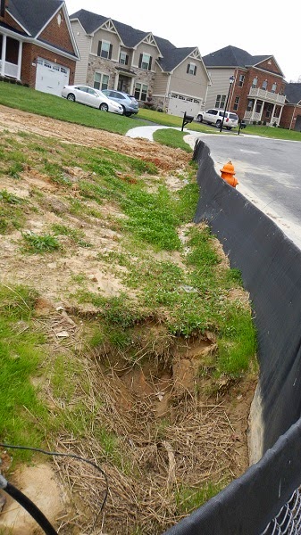
Here's a failed erosion fence...

The last shot is a development partly built, partly under construction. This silt fence is undermined.
Lastly, back on the other side of MD43 where some office parks have taken root and other spaces are yet to be planted.

Next, custom (Google) maps to outline the construction and other areas, and maps of points to be observed during higher rainfall. After the rain.
What else?
- Where is a list of bridge numbers to mash up against? Someone has inventoried these before.
- Lists or Google docs to save notes
- Stream quality and flow data [ US EPA STORET ]
- Back ref: Last post


1 comment:
Most successful stormwater projects involve some kind of curb inlet filter implementation as a means of prevention.
Post a Comment