I intended to test getting elevations as well as latitude/longitude with a slightly better
than my Coolpix along a stream/drainage channel. Ended up seeing a small vision of what the streambed looked like before we disturbed it.
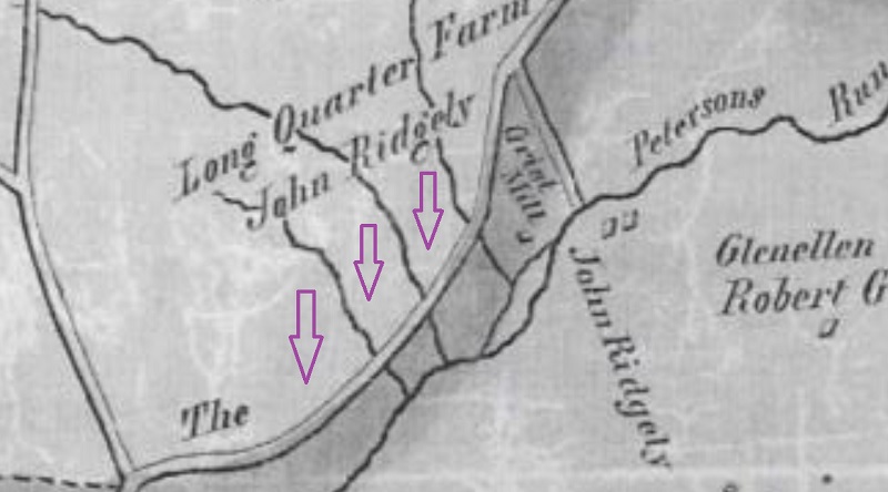
This figure was taken from the NPS publication on their web site - https://www.nps.gov/hamp/learn/upload/EOA-Hampton-TracingLivesFinalReport-508.pdf - (page 143) and shows "property" and water channels from around 1800 (?). From prior to the Loch Raven Reservoir being created. Arrows show an almost southerly direction on 3 unnamed tributaries of the then-named Petersons Run (I have not located that name on recent maps but haven't looked too far yet).
Researching landmarks/placemarks/benchmarks I found a 1938 "monument" by the USC & GS (then-named) in the vicinity. So I started there in an elevation quest (to level-set one might say).
My bookmark (pin) is:
<?xml version="1.0" encoding="UTF-8"?>
<kml xmlns="http://www.opengis.net/kml/2.2" xmlns:gx="http://www.google.com/kml/ext/2.2" xmlns:kml="http://www.opengis.net/kml/2.2" xmlns:atom="http://www.w3.org/2005/Atom">
<Placemark>
<name>BM Hampton</name>
<Point>
<coordinates>-76.59533879999999,39.4293622,0</coordinates>
</Point>
</Placemark>
</kml>
The records show the location is obscured.
I found a lot of topo data from the JHU Sheridan Libraries site
- JScholarship Home
- Library (Sheridan) General Collections
- Maps and Atlases
- Maryland State, County and Baltimore City Atlases
- https://jscholarship.library.jhu.edu/handle/1774.2/36112
Enough to get to the monument later, after the stream stomp. Good conditions for a field inspection given the lack of recent rain. More dry footing, and on the flip side, good mosquito breeding conditions. Not to mention poison ivy growth spurts.

The most downstream section goes into a culvert under a state/county highway, and I walked "up" from there. I'd been on the banks, obscured by overgrowth, before, just not at waters-edge.
Small pebbles, gravel, rocks, and at one stretch, broken-up concrete rubble fill (more or less). Not until I reached a section of shale (?) outcropping did I understand I was on land undisturbed by people. And by people, yes, white people.

I adjusted this image by 3 degrees once I spotted the building window that is unnaturally plumb.
And realized the streambed formerly went toward where the building and parking lot are now. Those streams that went southward can't anymore, though the sinkholes and disappearing streamflow says otherwise.

Also see: https://www.baltimorecountymd.gov/departments/environment/watersheds/index.html


No comments:
Post a Comment